We visited the Yarkon and Tel Afek National Park, which includes the Antipatris Fortress and the sources of the Yarkon River. One of 63 national parks in Israel, the archeological/nature reserve covers 5 sq. miles in the center of the Sharon plain, Israel’s most populous area. Thus, it is one of the most visited recreation areas in the country, just a few minutes’ drive from Tel Aviv and the Mediterranean Sea. Our guide was Pamela Levene, whose combination of knowledge, opinions and humor have made her tours very popular. The 'tel' in Tel Afek tells us that there were many civilizations built there, each on the remains of the previous one. The site was first inhabited during the Middle Bronze Age, as early as 3,000 BCE. In the Late Bronze Age, the Egyptians established a post there to guard the popular highway named the Way of the Sea (Via Maris). Later, Afek was the location of the Philistine encampment when they fought King Saul and the Israelites and captured the Ark of the Covenant (1 Samuel 4).
As we stood on the remains of the Roman cardo (main street) of Afek, we learned the meanings of the site’s historical names: Egyptian/Israelite: River Bed; Hellenistic: Pegae - Springs; Hasmonean: Springs, and Arethusa - wood nymph; Romans: Antipatris (built by Herod the Great in honor of his father, a Roman governor); Crusaders: Tower of the Muffled Springs; Turkish: Head of the Spring; British: Camp Afek; Iraqi army: Ras el-Ain - Head of the Spring.
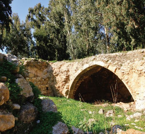
In 363 BCE an earthquake destroyed the previous fortification. King Herod rebuilt the city on the ruins because of the very strategic location, overlooking the Via Maris. Herod’s citadel, at the source of the Yarkon River, had ample water and lush vegetation, making it an ideal location for a fortification. To the east, built on the foothills of the Samaria Mountains, we could see Migdal (Tower) Afek, another fortress guarding the same pass, which was built over the ruins of a Jewish fort from the time of the First Jewish Revolt (66-70 CE). The castle is also known as "Mirabel" (beautiful view).
In the midst of carob and pine trees, we learned that all Roman towns were built with a cardo, the north-south shopping street which was the community’s nexus. In larger towns, such as Jerusalem, there would be two such intersecting streets. We saw poppies blooming by the cardo, milk-thistle plants with spiky purple heads, wild artichoke, and we sampled wild mustard. We walked further to the Odeon, which is a semicircular theater (not to be confused with an amphitheater which is always circular). There were stone arches alongside of the Odeon, which were probably once part of the stage’s support system.
Because Afek lies at the river head of one of Israel’s most significant waterways, it blocks traffic on the coast and forces the ancient international coastal highway through a narrow funnel between the river and the mountains. The two coastal routes south of Afek are forced to converge here and continue north to Mount Carmel. The strategic nature of this site continued from antiquity through the Turkish period when the most prominent of the remains at Afek, the fortress Binar Bashi (Tower of the Springs), was built during the years 1572 -1574 CE.
The impressive fortress ruins include four turrets, one of which is octagonal and surrounded by robust walls. During its construction, former archeological layers were demolished. However, archeologists found a commissioner's house from the Egyptian Era (15th century BCE), including written documents on clay tablets in several languages, which bear witness to the profound diplomatic relationships and commercial ties which existed there in that era. During the First World War, members of the British and Australian armies led by General Allenby were defeated while trying to cross the Yarkon River in this area. (http//:www.tiuli.com)
Before we began our short hike to Rosh HaAyin (Head of the Spring), we checked out the Mandate water system built between the two world wars. In 1948, when the British relinquished the Mandate for Palestine and withdrew their troops, they left the ruined fortress and water system to the Iraqis. This was typical of the British, who favored the Arabs during their decades-long administration of Palestine.
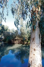
On the way to the water source we passed several picnic areas, a major attraction of the park. There were beautiful acacia trees with their yellow flowers, and wheat fields which had been recently threshed. We arrived at the area of the ponds, where water from the aquifer surfaces. At the beautiful lily pond, we saw Bleak fish which have only recently been brought back from near-extinction. We discovered someone fishing there, so one of our group phoned the authorities and a park ranger showed up ... the fisherman hastily withdrew.
The first few kilometers of the Yarkon are clean, and its flora and fauna are rich with many rare species, such as blue Egyptian water lily and the yellow water lily, as well as Bleak fish. Downstream, towards the sea, the water becomes polluted. Until recently, a fall into the stream could prove fatal, as happened in the tragic accident during the Maccabiah Games of 1997. In the last stretch before the Mediterranean, seawater discharges into the Yarkon and is used by the nearby Reading Power Station. The entire river is now non-toxic, a definite sign of progress.
We passed the Al-Mir flour mill, no longer submerged, which was originally built in Roman times and operated as late as the 19th century, the first of a series of five mills on the Yarkon. They were operated by a series of gears, not a water wheel, allowing them to operate in the shallow stream.
We soon came to the Concrete House, the first structure in Israel to be built of reinforced concrete (1912). Another first was the building’s centrifugal pumps powered by diesel engines, which provided the main water supply for Petah Tikva, including that for irrigating the town’s many orchards. Eventually the Electric Corporation bought the building and it remained in use until the 1970s.
We retraced our steps to the parking lot, passing under the Israel railroad bridge which traverses the park. It had been a very pleasant tour and our group enjoyed the walk, the information and the wit of our excellent guide.
Pamela Levene: http://www.rsvp-tours-israel.com

Post a Comment
Related Articles
 ESRA Golf Competition 2012
 Upside-Down Coffee – for another world. A Review
 If I could tell you - a review
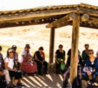 From Bible to Bedouins and Battles
 Trip to the Dead Sea
 Japan
JapanAbout the author
 Steve Kramer
Steve Kramer moved to Israel with his wife and two young sons in 1991 from Margate, NJ. After working for years in the beer distribution business in America, Steve had several jobs in Israel before...
More...